


Myrtle Voting District, Oregon County, Missouri
About
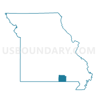
Outline

Summary
| Unique Area Identifier | 609271 |
| Name | Myrtle Voting District |
| County | Oregon County |
| State | Missouri |
| Area (square miles) | 25.92 |
| Land Area (square miles) | 25.85 |
| Water Area (square miles) | 0.07 |
| % of Land Area | 99.72 |
| % of Water Area | 0.28 |
| Latitude of the Internal Point | 36.52975740 |
| Longtitude of the Internal Point | -91.26978450 |
Maps


Graphs
Select a template below for downloading or customizing gragh for Myrtle Voting District, Oregon County, Missouri


Neighbors
Neighoring Voting District (by Name) Neighboring Voting District on the Map
- Cedar Bluff Voting District, Oregon County, MO
- Couch Voting District, Oregon County, MO
- Dalton Voting District, Randolph County, AR
- Jeff Voting District, Oregon County, MO
- Jobe & Billmore Voting District, Oregon County, MO
- Union Voting District, Randolph County, AR
Top 10 Neighboring County Subdivision (by Population) Neighboring County Subdivision on the Map
- Couch township, Oregon County, MO (426)
- Myrtle township, Oregon County, MO (388)
- Jeff township, Oregon County, MO (346)
- Dalton township, Randolph County, AR (254)
- Union township, Randolph County, AR (111)
- Jobe township, Oregon County, MO (106)
- Billmore township, Oregon County, MO (100)
- Cedar Bluff township, Oregon County, MO (91)